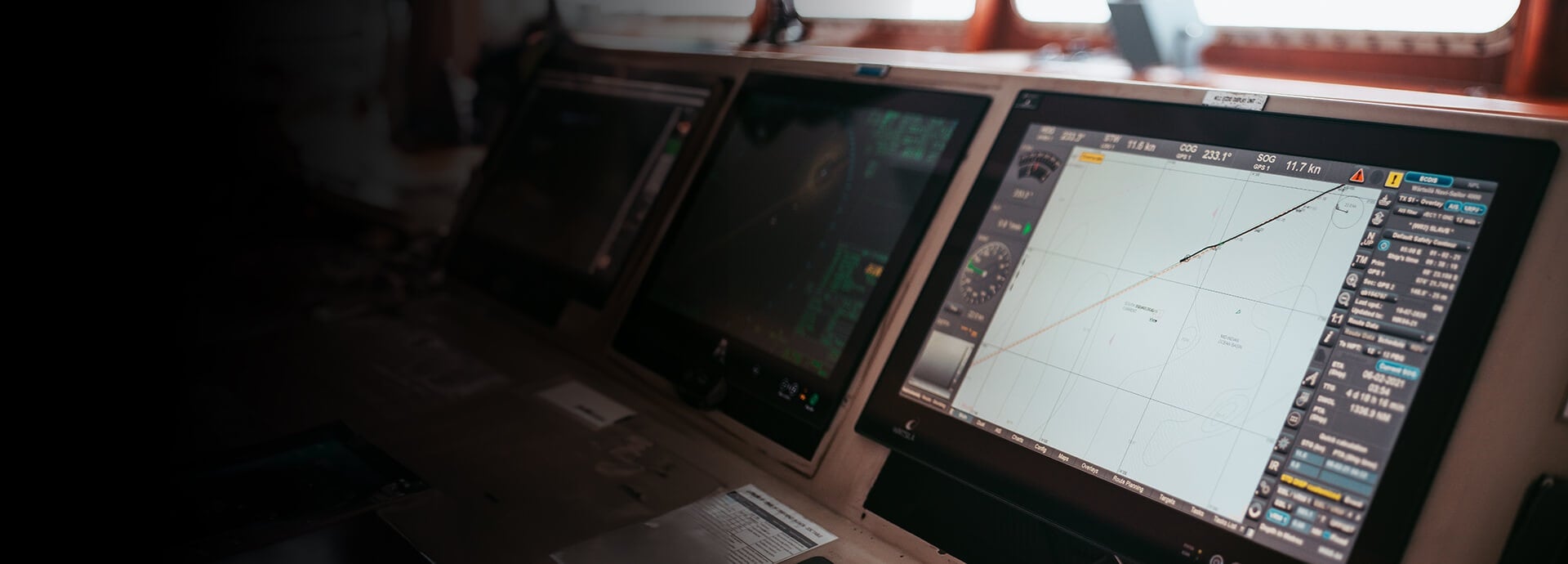
Wärtsilä Navi-Sailor ECDIS is an advanced, electronic chart navigation system and one of the most installed ECDIS solutions worldwide. Every day, thousands of vessels use it to navigate safely across the waters.
Navi‑Sailor ECDIS is a proven electronic chart display and information system for voyage planning and monitoring in line with IMO and SOLAS requirements. Backed with 190 years of Wärtsilä maritime innovation and designed for mariner‑friendly operation and long‑term compliance, it helps reduce bridge workload and supports safe and efficient navigation today and on the path to S‑100.
How to buy / get local support: Navi‑Sailor ECDIS is sold and supported through Wärtsilä’s authorised partner network. Use the partner list on this page to find your local point of contact for advice, configuration, installation, commissioning, and support.
ECDIS is a compliance and operational bridge solution: it directly impacts safe navigation, inspections, and the workload of bridge teams. Navi Sailor combines day to day operational reliability with ongoing alignment to “standards in force” (IMO/SOLAS and relevant IEC/IHO requirements), helping reduce the risk of non-compliance during audits and inspections.
At the same time, the industry is progressing toward the S‑100 era. Navi‑Sailor is maintained through software updates and is positioned with S‑100‑ready hardware to support a software‑led upgrade path as requirements mature.

Navi‑Sailor builds on a legacy of proven ECDIS deployment and ongoing compliance maintenance, with type examination and type approval managed in line with applicable requirements. For deeper technical detail, see the brochure and configuration materials.
Reduce operational risk. Navi‑Sailor minimises risk of non-compliance fines, PSC detentions, and inspection delays by combining type‑approved ECDIS performance with ongoing alignment to standards in force supported by a global authorised distributor/service network for predictable lifecycle support.
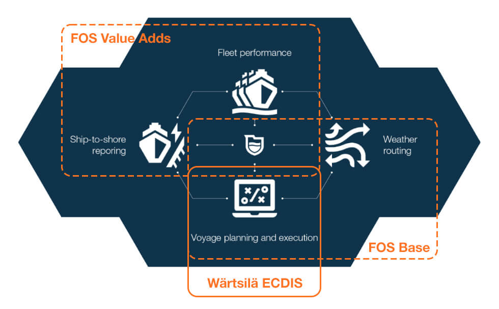
Improve efficiency onboard and ashore. Navi‑Sailor integrates with Wärtsilä Fleet Optimisation Solution (FOS) to connect ship and shore. Bridge teams benefit from streamlined workflows, while fleet teams gain better visibility and consistency across vessels.
Navi‑Sailor ECDIS delivers core voyage planning and monitoring functions with scalable options – from compliance essentials to advanced decision support.
Charting and compliance for IMO and SOLAS navigation
Passage planning and real‑time voyage monitoring
Integration, training, and lifecycle support over the system lifetime
Choose Wärtsilä Navi‑Sailor ECDIS with the support of an extensive network of local partners. Official Navi‑Sailor partners are your first point of contact for technical advice, system configuration, installation, commissioning, and support requests.
| Distributor | Street | Postal Code & City | Country | Phone | |
|---|---|---|---|---|---|
| Aeromarine S.A. | Rambla 25 de Agosto de 1825 No. 326 | Montevideo | Uruguay | +598 2 916 6456 | [email protected] |
| Alliance Nav Inc. - St Catharines | 131 Cushman Road / Unit 4 | St. Catharines | Canada | +1 514 338 1960 | [email protected] |
| Alliance Nav Inc. - St. Laurent | 6535 Chemin St. Francois | St. Laurent | Canada | +1 514 338 1960 | [email protected] |
| Alliance Nav USA Inc. | Cleveland | United States | +1 514 338 1969 | [email protected] | |
| Alphatron Marine B.V. | Schaardijk 23 | Rotterdam | Netherlands | +31(0)10-4534000 | [email protected] |
| Alphatron Marine - Belgium | Nieuwe Weg 1 | Zwijndrecht | Belgium | +32 3 685 21 96 | [email protected] |
| Alphatron Marine - Caribbean B.V. | De Rouvilleweg | Willemstad | Curaçao | +5999 788 9953 | [email protected] |
| Alphatron Marine - Côte d’Azur | Alphatron Marine Côte d’Azur | Mougins | France | [email protected] | |
| Alphatron Marine - France | 1720 Avenue de la Plaine | Mougins | France | +33 (0)3 21 30 45 13 | [email protected] |
| Alphatron Marine - Iberia S.L. | C. de los Manzanos / 34 | Madrid | Spain | ||
| Alphatron Marine - Noord | Korte Lijnbaan 25 | Harlingen | Netherlands | [email protected] | |
| Alphatron Marine - Poland Sp. z o.o. | J. Smolenskiej ps. “Jachna” 17 | Szczecin | Poland | +48 91 43 10 452 | [email protected] |
| Alphatron Marine Systems Pte Ltd | 1 Tuas Ave 20 | Singapore | Singapore | +65 6863 0335 | [email protected] |
| American Consulting Group | España 761 | San Isidro | Argentina | +54 11 4724 0999 | [email protected] |
| Anschutz Panama SrL | City of Knowledge / Clayton Building 225 | Panama City | Panama | +507 303 5510 | [email protected] |
| Arion Communication Co. Ltd. | 1-1701 Ace Hi-tech City / 775 / Gyeongin-ro / Yeongdeungpo-gu | Seoul | South Korea | +82 2 2679 8711 | [email protected] |
| Astilleros De Mallorca | Contramuelle Mollet 11 | Palma (Balearic Islands) | Spain | +34 971 710 645 | [email protected] |
| AVATEC Marine | Kadaka tee 3/2 | Tallinn | Estonia | +372 600 2299 | [email protected] |
| AWA Marine Australia | 4/345 Plummer Street | Melbourne | Australia | +61 3 9646-9966 | [email protected] |
| AWA Marine Philippines | Unit 1003 / One Global Place / 5th Avenue cor. 25th Street | Manila | Philippines | +63 999 226 1220 | [email protected] |
| Bardwell Electronics | 32 Michaels Way | Vineyard Haven | United States | +1 508 693 1486 | [email protected] |
| Beier Integrated Systems | 516 J F Smith Ave. | Slidell | United States | +1 504 341 0123 | [email protected] |
| Bluewater Books & Charts (BBC) | 3233 SW 2nd Avenue | Ft. Lauderdale | United States | +1 954 763 6533 | [email protected] |
| CC Electronics Pty Ltd | Unit 4 / 17 Sunderland Crescent | Butler | Australia | +61 (0) 452 550 184 | [email protected] |
| DSNM Ltd | Longmoor Farm Buildings / Cranbury Park / Otterbourne | Winchester | United Kingdom | +44 23 81800320 | [email protected] |
| DSNM Ltd | United Kingdom | United Kingdom | [email protected] | ||
| Elcome Europe S.L. | C. Lonja / 13 | Sevilla | Spain | ||
| Elcome Integrated Systems PVT Ltd. | Plot EL-205 / Electronic Zone | Navi Mumbai | India | [email protected] | |
| Elcome International LLC | Dubai Investments Park 598-1121 | Dubai | United Arab Emirates | [email protected] | |
| Elcome International LLC | Plot 598-1121 / Dubai Investments Park - 1 | Dubai | United Arab Emirates | +971 58516 5645 | [email protected] |
| Elcome International PTE LTD | 10 Bukit Batok Crescent | Singapore | Singapore | +65 9150 3190 | [email protected] |
| Elcome Marine LLC - Egypt- Free Zone | Plot 4 / Block H / Public free zone | Port Tawfik / Suez | Egypt | +20 623197959 | [email protected] |
| ElectroMed Algeciras S.L. | Carretera Circular 66 | La Linea De La Conception | Spain | +34 956632274 | [email protected] |
| Electromed Ltd | Rosia Road | Gibraltar | Gibraltar | +350 20077077 | [email protected] |
| Electrotech Australia Pty Ltd | Unit 37/9 Powells Road | Brookvale / NSW | Australia | +61 2 9905 6313 | [email protected] |
| Enavtech SARL | 686 Avenue de la Péguière | St-Raphael | France | +33 6 15 81 91 90 | [email protected] |
| ENL | Auckland | New Zealand | |||
| Fabio Fiorucci S.R.L. | Via Enrico Mattei / 26/F | Fano | Italy | [email protected] | |
| GFA Computer Systems (GFA) | 5090 Richmond Ave | Houston | United States | +1 832 274 7474 | [email protected] |
| Great Talent Ship Equipment Co. Ltd. | 198 Ta Tong 1st Road | Kaohsiung | Taiwan | 886-7-963888 | [email protected] |
| Hansael SIA | Piedrujas Street 7 | Riga | Latvia | +37167325352 | [email protected] |
| Hostmost Marine Services Ltd | 4302 Norfolk Street | Burnaby | Canada | +1 604 293 1730 | [email protected] |
| Indumar | Guadalupe Victoria #185 / Fracc. Los Pinos | Veracruz | Mexico | +52 229 932 8547 | [email protected] |
| Innovative Technology Solutions INC. | PH Soluciones Industriales | Panama | Panama | 507 208-9874 | [email protected] |
| International Marine Services Pvt Ltd | No. 96 / St. Andrew’s Road | Colombo | Sri Lanka | +94 717 915578 | [email protected] |
| Isbak Marine Service | Baldersbuen 29F | Hedehusene | Denmark | +45 21474506 | [email protected] |
| Istanbul Marin Elektronik San. Ve Tic. Ltd. Sti | Sahilyolu Cad. Yakut Sok No:26/3 Guzelyali | Istanbul | Turkey | +905439510483 | [email protected] |
| ISYMARINE sarl | 51 Allee des Bleuets | Mougins | France | +33 612 431 321 | [email protected] |
| Lammers Schiffselektronik GmbH | Hafenstr. 26 | Leer | Germany | +49 49196079-0 | [email protected] |
| M2 Nautical PTE Ltd. | Blk 9004 Tampines Street 93 #02-100 | Singapore | Singapore | +6590262796 | [email protected] |
| Mackay China | Room 127 / Bldg 6 / 787 Kang Qiao Rd | Shanghai | China | [email protected] | |
| Mackay Communications Inc. | 3691 Trust Drive | Raleigh | United States | +1 919 850 3000 | [email protected] |
| Mackay Marine - Brazil | Av. Emb. Abelardo Bueno 3500 | Rio De Janeiro | Brazil | +55 21 3410 8803 | [email protected] |
| Mackay Marine - Germany GmbH | Hafenstraße 6 | Leer | Germany | [email protected] | |
| Mackay Marine - Halifax | 7 Mellor Ave / Unit 16 | Dartmouth | Canada | +1 902 468 8480 | [email protected] |
| Mackay Marine - Los Angeles | 1891 N. Gaffey St. | San Pedro | United States | +1 310 519 7539 | [email protected] |
| Mackay Marine - Miami | 11360 Interchange Circle North | Miramar | United States | +1 954 431 7223 | [email protected] |
| Mackay Marine - Netherlands | Plaza 24 F | Moerdijk | Netherlands | [email protected] | |
| Mackay Marine - New Orleans | 1305-D Distributors Row | Harahan | United States | +1 504 733 5824 | [email protected] |
| Mackay Marine - New York / New Jersey | Raritan Center | Edison | United States | +1 732 225 4089 | [email protected] |
| Mackay Marine - Seattle / Tacoma | 5005 Pacific Highway East | Tacoma | United States | +1 253 922 6260 | [email protected] |
| Mackay Marine - St. John's | 29 Hallett Crescent | St. John's | Canada | +1 709 726 2422 | [email protected] |
| Mackay Marine - Tampa | Tampa | United States | +1 954 431 7223 | [email protected] | |
| Mackay Marine - Vancouver | 2999 Underhill Avenue | Burnaby | Canada | +1 604 435 1455 | [email protected] |
| Mackay Marine Belgium - Antwerp Depot | Noorderlaan 109 | Antwerpen | Belgium | [email protected] | |
| Mackay Marine Germany - Leer Office | Hafenstraße 6 | Leer | Germany | [email protected] | |
| Mackay Marine Singapore Pte Ltd | 2 Corporation Road / #05-12 Lobby A / Corporation Place | Singapore | Singapore | +65 66862806 | [email protected] |
| Mackay Marine Spain | Avda Oceano Atlantico 9 | Cadiz | Spain | +34 856 143 006 | [email protected] |
| Mackay Marine Turkey | Safran Sokak No. 3 | Istanbul | Turkey | [email protected] | |
| Mackay Marine UK Ltd | Spindle Way | Crawley | United Kingdom | +44 1737372679 | [email protected] |
| Mackay Marine - Hong Kong | Hong Kong | China | [email protected] | ||
| Mackay World Service | Noorderlaan 109 | Antwerp | Belgium | ||
| Mackay World Service | 921 Seaco Avenue | Deer Park | United States | +1 281 478-6245 | [email protected] |
| Mardad Marine SAL | Forty Four Tower / Lot 68 | Beirut | Lebanon | +961 81224030 | [email protected] |
| Mare Teknoloji A.Ş. | Aydintepe Mah Sahil Blv Alize Is Merkezi No. 191/59 | Istanbul | Turkey | +90 533 559 77 70 | [email protected] |
| Marine Electronic Services | Portland Sattar Tower (6th floor) / 1776 Strand Road | Chittagong | Bangladesh | [email protected] | |
| Marine Enterprise Co. Ltd | 1-1 / 5-Chome / Minatoshima-Nakamachi | Kobe | Japan | +81 78 302 0171 | [email protected] |
| Marine Innovation Pte. Ltd. | 194 Pandan Loop #06-01 | Singapore | Singapore | +65 6477 7737 | [email protected] |
| Marine Mechanics Pvt Ltd | Marine Mechanics INC FZE | Ajman | United Arab Emirates | +917358104276 | [email protected] |
| Maritech Adriatic ltd | Mihanoviceva 30 | Rijeka | Croatia | +385 (0)99 33 11 226 | [email protected] |
| McLaughlin Marine Electronics | 3577 SW 10th Street | Pompano Beach | United States | +1 954 975 2112 | [email protected] |
| Multidigital Nigeria Limited | Multidigital Services Limited | River State | Nigeria | [email protected] | |
| Murr Marine | c/o Mary Marine Ltd | Beirut | Lebanon | [email protected] | |
| Murr Marine Electronics | Quarantine | Beirut | Lebanon | +961 3 204012 | [email protected] |
| Naval Radio Limited - Chile | Cochrane 639 / Room 57 | Valparaiso | Chile | +56 32 2592749 | [email protected] |
| Navarino Elements PC | Akti Miaouli 3 | Piraeus | Greece | +30 210 41 11 311 | [email protected] |
| NAVCOM Team | Paseo Don Juan de Borbon 92 | Barcelona | Spain | +34 659259232 | [email protected] |
| NAVIGATX Ltd | Longmoor Farm Buildings / Cranbury Park | Winchester | United Kingdom | +44 7487 650 666 | [email protected] |
| NaviSea Marine Services BV | Oostergoweg 1 – 2 | Dokkum | Netherlands | +31 856666280 | [email protected] |
| NAVTEAM A/S | Norgesvej 7 | Svendborg | Denmark | +45 63 21 80 80 | [email protected] |
| Nova Electronics S.A. | Gravias 17-19 | Piraeus | Greece | [email protected] | |
| Novikontas - Riga | 17A / Duntes iela | Riga | Latvia | +371 7399999 | [email protected] |
| NSSL Global | Hanskampring 4 | Barsbüttel | Germany | +49 40 68277 125 | [email protected] |
| NSSL Global | 6 Wells Place / Gatton Park Business Centre / Merstham | Surrey | United Kingdom | +44 (0) 1737 648 853 | [email protected] |
| NSSL Global LLC - USA - New Orleans | 1000 Riverbend Drive | St. Rose | United States | [email protected] | |
| NSSL Global Ltd | 1000 Riverbend Drive / Suite A | Saint Rose | United States | +1 504 800 6290 | [email protected] |
| NSSL Global | ESL GmbH - European Satellite Link | Barsbüttel | Germany | [email protected] | |
| OTCC Sp. z o. o. | Chmielewskiego 22 | Szczecin | Poland | +48 918 876 176 | [email protected] |
| Pacific Radar | 15712 Mill Creek Blvd. | Mill Creek | United States | +1 425 775 0400 | [email protected] |
| Polaris Electronics LLC | 35 El Prisma | Rancho Santa Margarita | United States | +1 562 243 7589 | [email protected] |
| Poseidon Marine Electronics | 3825 Investment Ln Suite 7 | West Palm Beach | United States | +1 561 232 2413 | [email protected] |
| PT MULTIINTEGRA | Taman Berdikari Sentosa B1-D / Jl. Pemuda / Rawamangun | East Jakarta | Indonesia | +6221 4705108 | [email protected] |
| Radii Teknologi SDN BHD | Wisma Radii / No. 327 / Jalan Teluk Gadong/KS1 / Persiaran Raja Muda Musa | Port Klang | Malaysia | +60 122137591 | [email protected] |
| Radio Holland - Curacao | Pletterijweg z/n / Parera | Willemstad | Curaçao | +1 604 293 2900 | [email protected] |
| Radio Holland - Trinidad & Tobago | Atlantic Plaza | Point Lisas | Trinidad & Tobago | +1 713 378 2100 | [email protected] |
| Radio Holland - Vancouver | 8208 Swenson Wy Unit 240 | Vancouver | Canada | +1 604 293 2900 | [email protected] |
| Radio Holland - B.V. South Europe | Sluisjesdijk 155 | Rotterdam | Netherlands | [email protected] | |
| Radio Holland - Belgium N.V | Koralenhoeve 15E | Antwerp | Belgium | +32 3 320 9990 | [email protected] |
| Radio Holland - Brazil | General | Santos | Brazil | +55 13 3036 7474 | [email protected] |
| Radio Holland - China Ltd | Room 304B / No. 10 / Lane 198 / Zhang Heng Road | Shanghai | China | [email protected] | |
| Radio Holland - Egypt S.A.E. | Cairo | Egypt | [email protected] | ||
| Radio Holland - Egypt S.A.E. | 24 Syria St. / Roushdy | Alexandria | Egypt | +20 100 0066427 | [email protected] |
| Radio Holland - España S.L.U | P.Q. Las Marismas / Torres de Hercules 14 3 | Los Barrios / Cadiz | Spain | +34 956 108 318 | [email protected] |
| Radio Holland - France | Village Entreprises Le Rimbaud | Le Havre | France | +33 2 35 54 60 55 | [email protected] |
| Radio Holland - Germany GmbH | Albert Einstein-Ring 13 | Hamburg | Germany | +49 40 899 72 0 | [email protected] |
| Radio Holland - Group B.V. | Droogdokweg 71 | Rotterdam | Netherlands | [email protected] | |
| Radio Holland - Hellas | 1-3 Filellinon Str. & Akti Miaouli / 7th Floor | Piraeus | Greece | +30 210 0101472 | [email protected] |
| Radio Holland - Hong Kong Co. Ltd. | Unit E / 31/F / Plaza 88 / 88 Yeung Uk Road | Hk | China | [email protected] | |
| Radio Holland - Middle East LLC | W-116 Dubai Maritime City | Dubai | United Arab Emirates | +971 4 437 7550 | [email protected] |
| Radio Holland - Netherlands B.V. | Sluisjesdijk 87 | Rotterdam | Netherlands | +31 10 428 3344 | [email protected] |
| Radio Holland - Norway AS | Ostre Aker vei 19 | Oslo | Norway | +47 91727229 | [email protected] |
| Radio Holland - Panama | PH Centro Empresarial Mar Del Sur / 5th Floor | Panama City | Panama | +1 713 378 2100 | [email protected] |
| Radio Holland - Portugal | Avenida 24 de Julho / 60-1º | Lisboa | Portugal | +351 21 397 6087 | [email protected] |
| Radio Holland - Singapore PTE. Ltd | 102F Pasir Panjang Road #3-07 Citilink Warehouse Complex | Singapore | Singapore | +65 9670 1606 | [email protected] |
| Radio Holland - South Africa | 16 Paarden Eilan Road | Cape Town | South Africa | [email protected] | |
| Radio Holland - UK Ltd | The Old Coach House - Castle Eden | Durham | United Kingdom | +44 (0)1429 839280 | [email protected] |
| Radio Holland USA Inc - Houston (HQ) | 9191 Gulf Freeway / Bldg. D / Suite 100 | Houston | United States | +1 713 378 2100 | [email protected] |
| Radio Holland USA Inc - Jacksonville | 530 Ellis Road South | Jacksonville | United States | +1 713 378 2100 | [email protected] |
| Radio Holland USA Inc - Long Beach | 1230 E 29th Street | Signal Hill | United States | +1 713 378 2100 | [email protected] |
| Radio Holland USA Inc - Miami | 2860 West State Road 84 / Suite 116 | Miami | United States | +1 713 378 2100 | [email protected] |
| Radio Holland USA Inc - Mobile | Mobile | United States | +1 713 378 2100 | [email protected] | |
| Radio Holland USA Inc - New Orleans | 1015 Central Avenue / Suite 204 | Metairie | United States | +1 713 378 2100 | [email protected] |
| Radio Holland USA Inc - New York | 242 Possum Hollow Road | Monroe Township | United States | +1 713 378 2100 | [email protected] |
| Radio Holland USA Inc - Seattle | Seattle | United States | +1 713 378 2100 | [email protected] | |
| Radio Holland USA Inc - Tampa | Tampa | United States | +1 713 378 2100 | [email protected] | |
| RANAB | Enebacken 6 | Skärhamn | Sweden | +46 304 671 711 | [email protected] |
| RANAB (second Office) | Storgatan 51 | Mönsterås | Sweden | +46 304 671 711 | [email protected] |
| Reson Electronics INT’L INC | 12F / No. 1-26 / Kuoh-Jiann Rd. / Chien-Chen Dist. | Taiwan | China | +886-7-8150036 ext. #114 | [email protected] |
| Rossmap Joint Stock Company (Rossmap JSC) | The 5th & 6th Floors / Cau Giay Dist. / No. 69 Hoang Quoc Viet Str. | Ha Noi City | Vietnam | +84 903401019 | [email protected] |
| Rossmap Software Technology JSC | Doi Can Street / Ba Dinh District | Hanoi | Vietnam | +84 91 2476868 | [email protected] |
| RSB Novikontas Ltd | Taikos pr. 27A | Klaipeda | Lithuania | +370 46 304040 | [email protected] |
| Sambroni | Boulevard des Bassins de Radoub | Marseille | France | +33 612385431 | [email protected] |
| Seacoast Marine Electronics - Halifax | 110 Chain Lake Drive / Unit 3A | Beechville | Canada | +1 902 982 6652 | [email protected] |
| Sealink Electronics Co. Ltd | 25 Saneop-ro / Yeongdo-gu | Korea | South Korea | [email protected] | |
| Seven Seas Electronic Co. Ltd | 5th Floor / No. 2 Building / No. 848 YunQiao Road / Pudong New District | Shanghai | China | [email protected] | |
| Seven Seas Electronic Co. Ltd | Marine Hi-Techport / Block 10 / Lane 1333 | Shanghai | China | +86-21-3159-7770 ext. 6008 | [email protected] |
| Shanghai jinhailong Intelligent Technology Co.L.td. | Floor 2 / Building 10 / 518 Xinzhuan Road / Songjiang | Shanghai | China | [email protected] | |
| SMD Africa Marine | 53 Paarden Eiland Road | Cape Town | South Africa | +27 21 511 0556 | [email protected] |
| SMD Telecommunication CC | 53 Paarden Eiland Road | Cape Town | South Africa | [email protected] | |
| STM Marine Elektronik San. ve Tic. Ltd. Şti. | Postane Mah. Dr. Rustu Nuran Sok. No. 9 | Istanbul | Turkey | +90 216 491 60 04 | [email protected] |
| Sunship Electronic Services GmbH & Co. KG | Promenade am alten Binnenhafen 10 | Emden | Germany | +49 4921 940536 | [email protected] |
| Team Italia Marine S.r.l. | Via delle Corallaie / 26/30 | Livorno | Italy | +39 0721 855234 | [email protected] |
| Teecnavin SRL | Suárez 659 | Buenos Aires | Argentina | +54 9 11 6645 0441 | [email protected] |
| Tefin s.c.r.l. | Via Ferrante Imparato 501 | Naples | Italy | +39 3930068683 | [email protected] |
| Telemar Yachting Americas Inc | 3233 SW 2nd Ave | Fort Lauderdale | United States | +1 954 381 1672 | [email protected] |
| Telnav USA. LLC | 1717 Turning Basin Dr / Suite 443 | Houston | United States | [email protected] | |
| Tototheo | 89 Omonia Avenue | Limassol | Cyprus | +357 25569155 | [email protected] |
| Tronav | Manuel Rodríguez Objío 11 / Suite 5B | Santo Domingo | Dominican Republic | [email protected] | |
| UNICO Marine Pte Ltd | 48 Toh Guan Road East | Singapore | Singapore | +65 6610 2649 | [email protected] |
| Unimars Navigatio - SIA | Duntes iela 17 | Riga | Latvia | +371 67076383 | [email protected] |
| Vietnam Maritime Services and Consultants Limited Company | 19/654 Ngo Gia Tu | Hai Phong | Vietnam | +84 936 934 379 | [email protected] |
| Vivid Point SIA | Ganību dambis 24D | Riga | Latvia | +371 29235518 | [email protected] |
| Zener Marine Services LLC | Warsan 1 | Dubai | United Arab Emirates | +971 4 557 7402 | [email protected] |
Navi‑Sailor ECDIS is available in three tiers - Base, Standard, and Premium - to match operational needs and budget. Beyond the core ECDIS tiers, optional modules can be added to extend MFD experience:
Navi‑Sailor is available on a compact Panel PC or marine‑grade “blackbox” computer for flexible newbuild and retrofit bridge layouts. All hardware units meet relevant IEC and IACS requirements, and current platforms are S‑100 ready for a smooth upgrade path.

Navi‑Sailor ECDIS can be extended beyond traditional ECDIS operation to support multifunction bridge configurations, integrating radar and conning functionality on the same certified platform. This allows operators to consolidate key navigation information while maintaining compliance, redundancy, and operational flexibility.
This approach supports both newbuild and retrofit projects where space optimisation, ergonomics, or simplified bridge layouts are priorities.
Navi‑Radar is a certified marine radar solution that can be integrated with Navi‑Sailor ECDIS and connected to the radar scanner (top-unit) from a range of supported offerings from multiple vendors. It supports radar target tracking, AIS integration, and chart–radar overlay, helping bridge teams correlate real‑world and charted targets, particularly in congested or reduced‑visibility conditions.
The optional Conning Information Display (CID) presents key navigation and ship‑handling data, such as speed, heading, RPM, and navigational status, in a single, customisable view sourced from multiple bridge sensors. This improves situational awareness and reduces the need to switch between systems during manoeuvring and monitoring.
Navi‑Sailor supports single, dual, and multi‑node bridge configurations on compact Panel PC or marine‑grade computer platforms, enabling flexible bridge designs aligned with operational and regulatory requirements.
Navi Sailor ECDIS supports SOLAS chart carriage and is maintained in line with applicable IMO and IHO requirements, including:
Navi Sailor combines proven compliance with an S 100 ready hardware platform. It supports cyber resilient newbuild requirements (IACS UR E27 Rev.1) and is backed by type examination and type approval from leading organizations (DNV, BV, CCS and others).

Compliance, inspections, and regulatory readiness
S‑100 readiness and future navigation standards
Navigation, charting, and bridge operations
Training, lifecycle support, and total cost of ownership
How to move forward:
Navi‑Sailor ECDIS can also act as a foundation for broader digital navigation and fleet optimisation initiatives, supporting future integration with Wärtsilä’s voyage and fleet solutions as your needs evolve.
Adopt Navi‑Sailor ECDIS today for compliance, cost‑effective training and maintenance, and reduced risks of PSC detentions. To purchase, commission, or service the system, use the partner list to find your local authorised distributor.