On land, technology has completely redefined our day-to-day activities, paving the way for disruptive business models from banking to travel. From smart-phones to the connected car, we live in a digital world. Yet, shipping has arguably been slow to capitalise on these possibilities.
This is changing with Wärtsilä’s Navi-Planner – Smart Voyage Optimisation that all but obliterates the manual labour when it comes to route planning. It’s a solution that’s targeted to the very specific needs of today’s maritime industry, bridging the gap between the latest technological offerings and the need for compliance with existing systems. Fully market ready, it’s set to take the shipping world by storm.
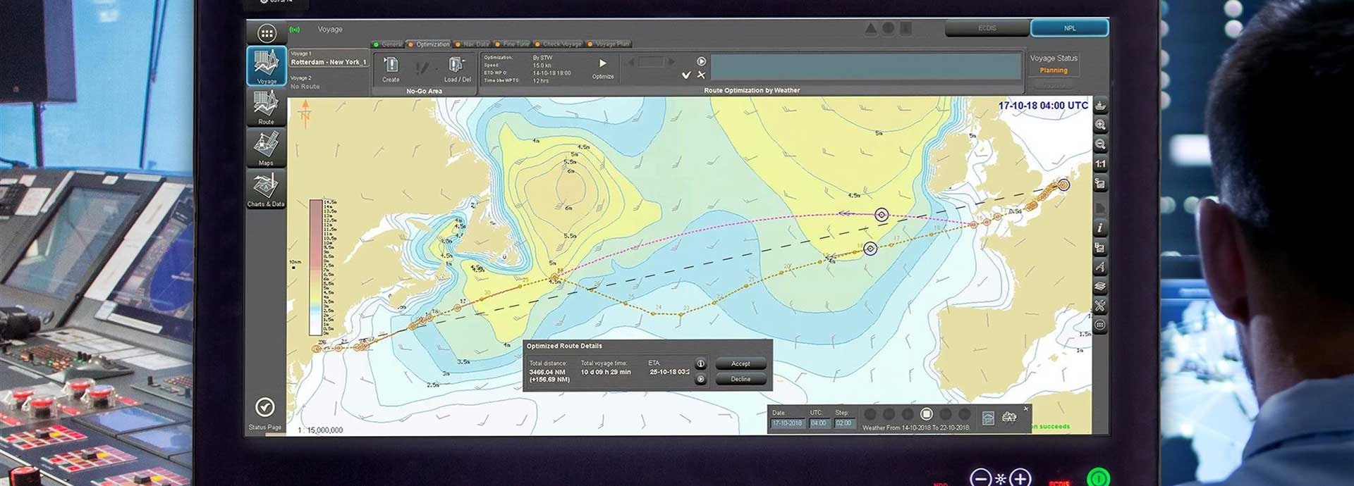
Wärtsilä’s Navi-Planner takes into account metocean data, traffic patterns and weather updates to prepare a safe and efficient route using one of the world’s largest navigational databases. That data is then available for the Captain’s finalisation and, most importantly, everything is cyber-secure and fully compatible with the ECDIS.
“Navigating a route is a mathematical problem with a whole load of variables that need to be gathered and collated, then factored into the equation,” explains Christopher Schröder, Wärtsilä’s Sales Director for Northern Europe.
At present, a navigator has to physically click through, setting and linking way points, matching them to charts, purchasing those charts and then manually uploading them. Humans are good at many things but crunching large amounts of data is something computers excel at and – unlike mere mortals – their capacity is only getting greater.
Navi-Planner allows operators to transform real-time navigational data into an optimised route in a couple of clicks. Not only does it use all available data to streamline the route and reduce human error, it also frees up valuable crew time for other tasks.
Under increasing pressure to compete on cost efficiency and environmental impact, shipping is feeling the strain. Across all areas of compliance, demands are tight and tightening. For the sake of the planet, as well as the bottom line, it is high time the industry had access to technology to help with the heavy lifting.
“Optimising a route is utterly crucial to all elements of improved performance and safety – not to mention environmental sustainability,” Schröder says. “We need to embrace the reliable technology we now have to help this industry solve its problems.”
Many self-sufficient but separate sensors and systems already exist on board vessels – like depth sounders, weather sensors to name a few. They are connected on the bridge but still require data to be manually transferred beyond it.
With Navi-Planner, such systems are directly connected to the ECDIS, so, all data required to make optimal route decisions is already right where it needs to be. With better links from ship to shore, smart and timely joint decisions can be made.
According to Schröder, Navi-Planner represents such an essential leap forward that the most common feedback from customers is: “Why wasn’t it invented earlier?”
It is a fair question. We’ve long been using technology to simplify our land and air travel and make it more efficient, so why haven’t we been using it to harness onshore and offshore data to optimise sea routes?
“Part of the answer is that we need to find our own way,” explains Schröder. “Our requirements are different, and the maritime industry has its own challenges.”
The reality on ships is very different to experiences in our daily lives on land. In the scheme of things, even using electronic charting systems is a relatively recent advancement and getting those systems to the point of IMO compliance has taken time. Until now, we didn’t really have the technology to consider better ways of getting data into the ECDIS, Schröder says.
Also, while plenty of technological opportunities are now within grasp for the maritime industry, unlike on land, full connectivity may be close, but it is not there yet. In contrast, manual systems and paper charts have been relied upon for hundreds of years, so it is understandable that maritime might be a tad slower on the uptake.
That said, the future is officially here. The benefits of Smart Voyage Optimisation are clear, and it is hard to imagine it becoming anything but an industry norm.
The Wärtsilä Navi-Planner is a system with the capability to constantly evolve, so the best news is that customers won’t be left behind as the technology improves.
The system is designed to seamlessly incorporate new information into route planning so Smart Voyage Optimisation opportunities are endless. For example, eventually Navi-Planner will be capable of dynamically adjusting the route and speed of a vessel’s port approach for a Just in Time arrival.
As the ability to connect, share data and communicate in real time penetrates further into the world of marine transportation, opportunities for smarter, safer and more sustainable operations will expand exponentially.
Wärtsilä’s Navi-Planner is charting the way to a smarter future – time to get on board!
Once every six weeks, you will get the top picks – the latest and the greatest pieces – from this Insights channel by email.